The National Operational Hydrologic
Remote Sensing Center
and
Snow Hydrology
in the
National Weather Service
Background Material for
Session Five:
Snow Hydrology Breakout Session
2002 December 5, Thursday, 7:45-9:15am and 9:45-11:15am
National Hydrologic Program Managers Conference
Fairmont Hotel
New Orleans, Louisiana
2002 December 3-6
Background
This document provides background information useful for
participants at the Snow Hydrology breakout sessions to be held on
Thursday morning, December 5, at the National Hydrologic
Program Managers Conference. It is not intended to be a definitive
discussion on snow hydrology or the National Operational
Hydrologic Remote Sensing Center (NOHRSC). The following does
provide, however, a brief overview of: (1) the NOHRSC, (2) the
requirements for snow data and information to support the NWS
Hydrologic Services Program, (3) the Airborne Snow Survey
Program, (4) the Satellite Hydrology Program, (5) the Snow Data
Assimilation System, and (6) the NOHRSC snow product description
and distribution.
Additionally, this document concludes by suggesting a few issues,
or discussion topics, that may, or may not, be useful during the
Snow Hydrology breakout session. Please have a look at the
suggested questions and discussion topics for consideration. Also,
you should make a note of any other questions or discussion topics
that you would like to raise, or hear discussed, at the Snow
Hydrology breakout sessions.
NOHRSC Overview
The National Operational Hydrologic Remote Sensing Center
(NOHRSC) is managed by the Hydrologic Service Division in the
Office of Climate, Water, and Weather Services. The NOHRSC is
collocated with the North Central River Forecast Center (NCRFC)
and the Chanhassen Weather Forecast Office (WFO) in
Minneapolis, Minnesota. The NOHRSC provides remotely-sensed
and modeled hydrology products for the coterminous U.S. and
Alaska for the protection of life and property and the enhancement
of the national economy. NOHRSC airborne, satellite, and modeled
snow data and products are used by the NWS, other government
agencies, the private sector, and the public to support operational
and research hydrology programs across the nation.
The primary effort of the NOHRSC is to provide a variety of ground-based,
airborne, and satellite snow observations and products in
map format and in Standard Hydrologic Exchange Format (SHEF).
Additionally, the office generates a variety of modeled snowpack
products for the coterminous U.S., in near real-time, for use by the
NWS River Forecast Centers (RFC) and Weather Forecast Offices
(WFO) to support the NWS Hydrologic Services Program. The NWS
Instruction 10-931 (2002 August) describes the NOHRSC policy and
provides details of the office operation.
Requirements for Snow Information and Products in the NWS
Over the years, requirements for snow information and products to
support the NWS Hydrologic Services Program have been
articulated and documented in a wide variety of desperate reports
and publications. Recently, a white paper titled Requirement for
Snow Data, Products, and Information in the Hydrologic Services
Program National Weather Service, NOAA, was collated from
findings, requirements, and information documented in the 1993,
1996, and 1997 NOAA Disaster Survey Reports and the NWS
Assessment of Hydrologic and Hydrometeorological Operations and
Services by the National Research Council. The 1996 and 1997
floods were severe snow melt floods; consequently, the survey
reports clearly document much of the RFC and WFO snow data,
products, and information requirement. Additionally, the snow
requirements document includes requirements articulated by NWS
regional, RFC, and WFO personnel who attended the Eastern
Region snow workshop held at the MARFC on December 1-4, 1998;
the Western/Alaska Regions snow workshop held at the NWRFC on
July 26-30, 1999; and the Eastern Region snow workshop held at
Ithaca, NY, on July 18-19, 2000. Lastly, the snow requirements
document also includes input and requirements articulated at the
4th NWS Cold Region Hydrology Workshopheld at the NWS Training
Center in Kansas City on November 14-17, 2000. All NWS Regions
have had the opportunity to review, to comment on, and to provide
input to the snow requirements document.
Airborne Snow Survey Program
The NOHRSC uses low-flying aircraft to make airborne snow water
equivalent measurements over a network of 2000 flight lines
covering 26 states and 7 Canadian provinces. Airborne snow
survey missions are scheduled upon request by RFC and WFO
hydrologists when snow is significant in the region. The Airborne
Snow Survey Program User's Guide provides details of: (1) the
Airborne Snow Survey Program, (2) an explanation of the
measurement technique, (3) how to access maps of airborne snow
water equivalent, (4) how to interpret the SHEF message
containing airborne snow water equivalent data, and (5) how to
generate interactive, web-based flight line maps for your CWA or
RFC along with other information.
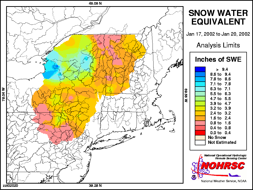
Typical Airborne Snow Survey Program products include: (1) color
contour maps of airborne snow water measurements, (2) the
associated SHEF message that gives airborne snow water
equivalent data by flight line and (3) the associated SHEF message
that gives mean areal snow water equivalent over RFC hydrologic
basins. The snow-water-equivalent-by-flight-line SHEF message is
sent to AWIPS automatically and immediately upon NOHRSC
receipt from the survey aircraft (sometimes three times each day)
and posted to the NOHRSC web site. The snow- water-equivalent-by-basin
SHEF message, for the entire survey area, is sent to
AWIPS and the NOHRSC web site at the conclusion of each survey.
The snow water equivalent map is posted to the NOHRSC web site
at the conclusion of each survey; it is not sent to AWIPS./P>
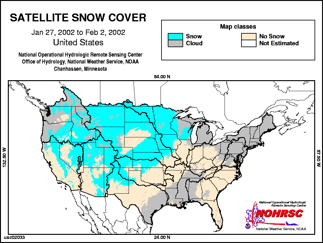
Satellite Hydrology Program
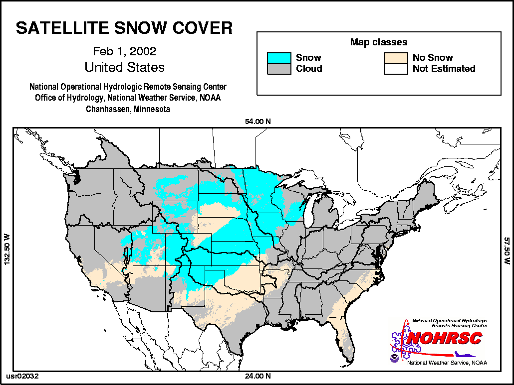
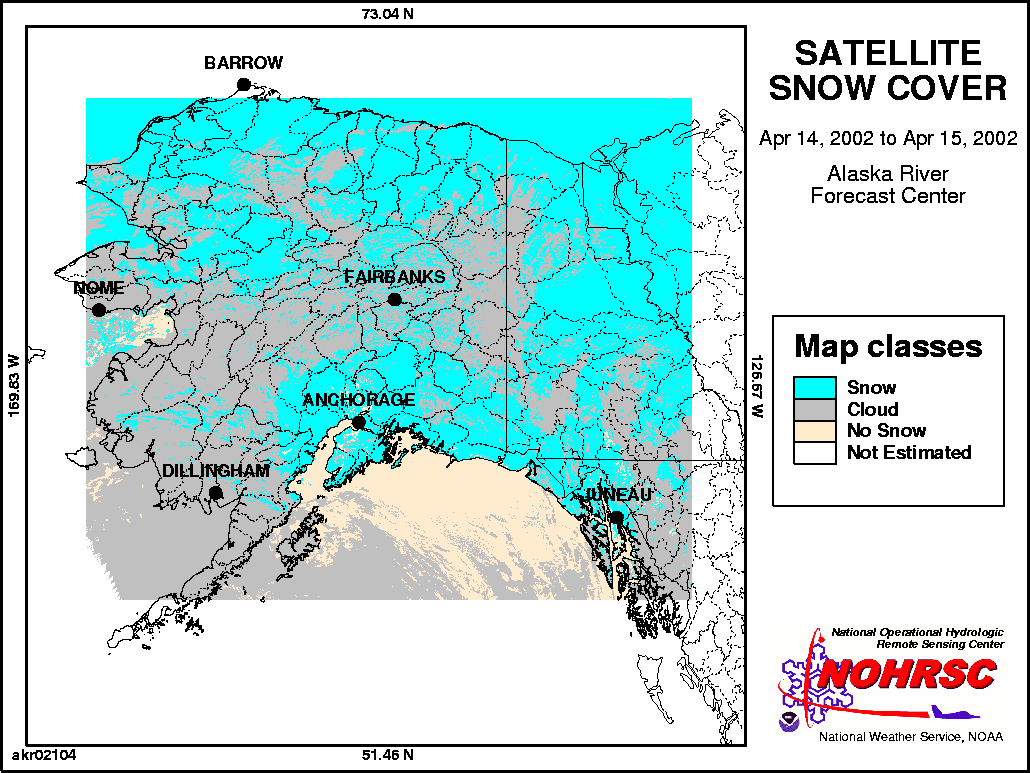
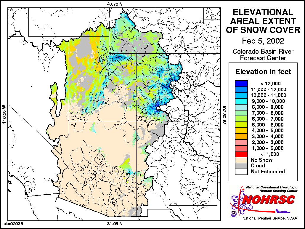
The NOHRSC Satellite Hydrology Program uses image data from
the NOAA GOES and NOAA POES to generate near real-time,
satellite-derived areal extent of snow cover for the country.
Satellite snow cover image products are generated daily at US scale
(including Alaska), RFC scale, and at CWA scale. Additionally,
weekly composite satellite snow cover images are produced to
minimize the impact of cloud cover. Associated with each RFC
scale satellite areal extent of snow cover image is a SHEF message
that gives the percent of snow cover by RFC hydrologic basin and
by elevation zone in the West. The NOHRSC has compared other
satellite snow covering mapping techniques used by NESDIS and
NASA with those used by the NOHRSC and found similar results.
Snow Data Assimilation System
The Snow Data Assimilation System (SNODAS) is a software
system that uses input from the NWS numerical weather prediction
(NWP) models to drive the NOHRSC energy-and-mass-balance
snow model for the coterminous U.S. The NOHRSC snow model
uses hourly forcing data from the Rapid Update Cycle 2 NWP model
to simulate near real-time, hourly snowpack state variables for the
country at 1 km resolution. Ground-based, airborne, and satellite
snow observations are assimilated into the simulated snowpack
state variables to produce a "best estimate" of snowpack
characteristics. The resulting snowpack state variable estimates
use all available NWP modeled and observed data sets as well as all
available snow observations for the country. The NOHRSC snow
model is described in detail on the NOHRSC Technology web page.
SNODAS products and output will soon be provided to NWS field
offices, over AWIPS and the Internet, in a variety of formats and
spatial scales to best support the requirement for snow data in the
NWS hydrology program. Image examples of SNODAS state
variables include: snow water equivalent,
sublimation/condensation, mean snow pack temperature, snow
depth, and snow melt. Additional snow products, at various spatial
scales, generated by the NOHRSC snow model can be found on the
NOHRSC experimental web page.
NOHRSC Products Distributed to the Web and to AWIPS
This document describes only selected products and formats
currently generated by the NOHRSC. The office posts all image and
alphanumeric products to the NOHRSC web site in near real-time.
Descriptions and examples of all NOHRSC products can be found
on the NOHRSC web site. Additionally, the NOHRSC sends AWIPS
products in SHEF and GRIB to the Satellite Broadcast Network for
distribution, in near real-time, to the NWS field offices for viewing
on AWIPS and on D2D. In the near future, additional NOHRSC
snow model products and associated data, in a variety of formats,
will be available on a new interactive NOHRSC web site.
Potential Snow Hydrology Breakout Session Discussion Topics
The following is a limited suggestion of potential topics for
discussion at the Snow Hydrology breakout sessions. What other
questions, topics, or issues would you like to discuss? Make a note
of the snow hydrology issues that are important to you and your
program and plan to raise them with other hydrologic program
managers at the Snow Hydrology breakout session Thursday
morning.
- What are the primary snow hydrology problems in your CWA?
- What are the potential solutions to said problems?
- How can RFCs better address your snow hydrology problems?
- How can the NOHRSC help to address your snow hydrology
issues?
- What NOHRSC products are most useful?
- What formats are most useful?
- What snow products would you like to see that are not
currently available?
- Would ArcView shapefiles of NOHRSC products be useful?
- How would you use ArcView to address your snow issues?
- What types of NOHRSC snow model products and
displays would you like to see on an interactive NOHRSC
web site?
Snow Hydrology Breakout Session Contact
If you have any questions, thoughts, or suggestions on the Snow
Hydrology breakout session planned for the forthcoming National
Hydrologic Program Managers Conference, give me a call.
Tom Carroll
National Operational Hydrologic Remote Sensing Center
Chanhassen, Minnesota
(952) 361-6610 ex 225
Tom DOT Carroll AT noaa DOT gov
20020826
|


