
Cold Land Processes Mission (EX-7)
Science and Technology
Implementation Plan
Don Cline
National Operational Hydrologic
Remote Sensing Center
National Weather Service, NOAA
Robert E. Davis
U.S. Army Engineer Research and
Development Center
Cold Regions Research and Engineering
Laboratory
Wendy Edelstein
NASA Jet Propulsion Laboratory
Jeff Hilland
NASA Jet Propulsion Laboratory
Kyle McDonald
NASA Jet Propulsion Laboratory
Steve Running
University of Montana
JoBea Way
NASA Jet Propulsion Laboratory
Jacob vanZyl
NASA Jet Propulsion Laboratory
Report on the NASA Post-2002 Land
Surface Hydrology Planning Workshop
Irvine, CA
April 12-14, 1999
TABLE OF CONTENTS
List of Contributors
Executive Summary
I. Importance
of the Cold Land Processes Mission to Hydrology and Earth Science
II. Description
of the Cold Land Processes Mission
Mission ObjectivesIII. Required Pre-Launch Science Investments for the Cold Land Processes Mission
Science Measuring and Modeling Requirements (including Trade Studies)
Baseline Mission Description
Paper Studies to Support the Cold Land Processes MissionIV. Required Pre-Launch Technology Investments for the Cold Land Processes Mission
Field Validation of SAR Algorithms to Detect Freeze-Thaw States
Field Validation of SAR Algorithms to Measure Snow
SAR Technology for Frozen Ground and Snow MeasurementsV. Mission Implementation Schedule
Radiometer Technology for Frozen Ground and Snow Measurements
Al Chang
NASA Goddard Space Flight Center
Don Cline (Snow Contact)
National Operational Hydrologic
Remote Sensing Center
National Weather Service, NOAA
(612) 361-6610 x252
cline@nohrsc.nws.gov
Robert E. Davis
U.S. Army Engineer Research Development
Center
Cold Regions Research and Engineering
Laboratory
Jeff Dozier
University of California, Santa
Barbara
Wendy Edelstein
NASA Jet Propulsion Laboratory
Barry Goodison
Canadian Climate Center, Atmosphere
Environment Service, Canada
Hardy Granberg
Centre d?Applications et de Recherches
en Teledetection (CARTEL), Canada
Kyle McDonald
NASA Jet Propulsion Laboratory
Son Nghiem
NASA Jet Propulsion Laboratory
Tom Painter
University of California, Santa
Barbara
Steve Running (Freeze/Thaw Contact)
School of Forestry
University of Montana
Missoula, MT 59812
(406) 243-6311
swr@ntsg,umt.edu
J.C. Shi
University of California, Santa
Barbara
Jacob van Zyl
NASA Jet Propulsion Laboratory
Jobea Way
NASA Jet Propulsion
Laboratory
The Cold Land Processes Mission is a research mission concerned with frozen landscapes - cold areas of the Earth?s land surface where water is frozen either seasonally or permanently. These areas are the land component of the cryosphere (i.e. the terrestrial cryosphere), where snow, ice, and frozen soils and vegetation are common. Cold land areas form a major component of the Earth?s hydrologic system. Seasonal snow cover and glaciers store large amounts of fresh water, and are therefore critical components of the hydrologic cycle. Seasonal and permanent frost in soils reduce both infiltration into and migration of water through soils, and severely reduce the amount of water that can be stored in soils. By reducing infiltration, frozen soils can dramatically increase the runoff generated from melting snow. The importance of seasonally and permanently frozen land surfaces extends far beyond hydrologic processes. These areas also interact significantly with the global weather and climate system, the geosphere, and the biosphere. The influence of seasonally and permanently frozen land surfaces extends to engineering in cold regions, trafficability for humans and other species, and a variety of hazards and costs associated with living in cold lands. The Cold Land Processes Mission will use remote sensing to measure critical components of the terrestrial cryosphere.
The Cold Land Processes Mission will improve our fundamental understanding of the hydrology, meteorology, and ecology of the terrestrial cryosphere. Also, it will provide a baseline set of observations that can be used to gage future changes in the extent and characteristics of major components of the terrestrial cryosphere. The Cold Land Processes Mission is an experimental research mission, with an expected data collection period of 5 years. There are four major science questions for this mission:
We identify four alternative sensor/measurement options: Option 1, a dual frequency radar sensor system with high spatial resolution focuses on snow characteristics and also meets the freeze/thaw measurement needs. Option 2, a low frequency radar sensor with medium spatial resolution focuses on the freeze/thaw state of the land surface. The extent that it addresses the science objectives related to measuring snow characteristics must be studied. Option 3, a high frequency passive sensor with medium spatial resolution focuses on snow characteristics. Its usefulness for determining freeze/thaw states must be studied. Option 4, a sensing system that combines Options 2 and 3.
Option 1 has the following five baseline measuring requirements:
Common to all options is the requirement for a modeling and data assimilation component. It will integrate the remotely sensed information and ancillary information in a comprehensive manner. This component must provide a clear path for providing freeze/thaw and snow data products to the hydrologic and atmospheric modeling communities in a time frame appropriate for both research studies and operational forecasting. Trade studies are identified that will provide needed support and refinement to these requirements.
Investments in both science and technology are required to prepare a mission-ready proposal for the Cold Land Processes Mission. A field/airborne measurement campaign is required to quantitatively evaluate existing and new algorithms for retrieving freeze/thaw state and snow properties from both active and passive microwave measurements, and to inter-compare the derived products and tradeoffs associated with each sensor system option. Paper and trade studies (that do not require additional data collection) are required to fully prepare the science component of the mission. Major technology challenges have also been identified for this mission. To meet the requirements for Option 1 in a near-term mission, a tandem (two spacecraft) L-band and X-band mission should be considered if there are restrictions on spacecraft resources and mission cost, thus allowing for a phased approach to the mission. Alternately, a single spacecraft with a dual-frequency, dual polarization sensor can be flown, with higher programmatic and technical risks. Current large deployable antenna technology for Options 3 and 4 to achieve the 5 km spatial resolution could be ready for launch by 2005. But further technology developments (e.g. 2-D synthesized stick antenna) are needed in order to achieve the 1-2 km spatial resolution from the passive systems. Mission costs may be significantly reduced by technological developments related to improved antennae design (for both active and passive sensors) and on-board processing. Thus, investments in technology areas are required to ensure technological readiness for the mission and to reduce mission costs.
The preliminary schedule for preparing for the Cold Land Processes Mission is aggressive but not unrealistic. Trade studies are scheduled to begin immediately. Field/airborne studies are scheduled to begin in the Spring of 2001. Paper studies are scheduled in two phases: a) a first round of smaller, low-cost studies to be supported by the current NASA Land Surface Hydrology Program (LSHP) budget beginning FY2000, and b) a second round of paper studies that will require augmentation of the LSHP budget in FY2001. The target date for submission of a mission-ready proposal is January, 2002. The target selection date for the mission is July, 2002. The target launch date for the mission is early 2005.
I. IMPORTANCE OF
THE COLD LAND PROCESSES MISSION
TO HYDROLOGY AND
EARTH SCIENCE
The Cold Land Processes Mission is
a research mission concerned with frozen landscapes - cold areas of the
Earth?s land surface where water is frozen either seasonally or permanently.
These areas are the land component of the cryosphere (i.e. the terrestrial
cryosphere), where snow, ice, and frozen soils and vegetation are common.
The terrestrial cryosphere represents a significant proportion of the Earth?s
land surface (Figure 1). Estimates from coarse-resolution satellite data
indicate that on average, over 60% of the northern hemisphere land surface
has snow cover in midwinter [Robinson, et al., 1993]. Over 30% of
Earth?s total land surface has seasonal snow, and about 10% is covered
permanently by snow and ice. Seasonally and permanently frozen soils occur
throughout higher latitudes and at high elevations; they are thought to
occur over approximately 35% of the Earth?s land surface [Williams and
Smith, 1989]. Permanently frozen soils (permafrost) underlie approximately
26% of the Earth?s land surface [Washburn, 1979]. These areas are
very dynamic; the spatial extents of frozen and thawed areas vary significantly
on daily, seasonal and interannual time scales.
Figure 1. Approximate distribution of frost and ice effects. All land areas shaded light blue or white (north of the yellow line in the northern hemisphere, and Antarctica), and with elevations over 1000 m compose the terrestrial cryosphere to be measured by the Cold Land Processes Mission. This demarcation is based on a 0° C mean temperature during the coldest month, approximately 0.25 m of frost penetration one year in ten, and 100 days of ice on navigable waterways (based on figure provided courtesy of ERDC-CRREL).
Cold land areas form a major
component of the Earth?s hydrologic system. Seasonal snow cover and glaciers
store large amounts of fresh water, and are therefore critical components
of the hydrologic cycle. Seasonal snow is a major source of fresh water
over wide areas of the mid-latitudes, and is the principal source of regional
runoff in mountainous areas. Water frozen in the soil also plays a very
large role in hydrologic processes. Seasonal and permanent frost in soils
reduces both infiltration into and migration of water through soils, and
severely reduces the amount of water that can be stored in soils [Kane
and Chacho, 1990]. By reducing infiltration, frozen soils can dramatically
increase the runoff generated from melting snow.

The importance of seasonally and permanently frozen land surfaces extends far beyond hydrologic processes. These areas also interact significantly with the global weather and climate system, the geosphere, and the biosphere (Figure 2). Whether surface water is liquid or frozen has important consequences for surface albedo and net radiation, as well as for latent energy exchanges. For example, Betts et al. [1998] found that because numerical weather prediction models do not correctly account for frozen surfaces, they tend to overestimate springtime latent energy fluxes. This leads to forecast errors of up to 5EC in lower tropospheric temperatures, which then propagate throughout the planetary boundary layer and above. In seasonally frozen environments, vegetation growing seasons are determined primarily by the thawed period. In turn, the timing of spring thaw and the duration of the growing season are strongly linked to the carbon balance of seasonally frozen ecosystems. Frolking et al. [1996] found that earlier spring thaws lead to significant increases in simulated net carbon uptake. Permanently frozen areas are also important components of global biogeochemical budgets. It is estimated that one third of global carbon is immobilized within permafrost soils. The influence of seasonally and permanently frozen land surfaces extends to engineering in cold regions, trafficability for humans and other animals, and a variety of hazards and costs associated with living in cold lands.Figure 2. Conceptual diagram showing the general effects of freeze/thaw status on meteorological, hydrological, and ecosystem processes throughout the year.
The Cold Land Processes Mission will use remote sensing to measure critical components of the terrestrial cryosphere. This mission is particularly relevant at this time because the terrestrial cryosphere is changing. According to the Intergovernmental Panel on Climate Change (IPCC) [Houghton et al., 1996], recent projections from atmospheric general circulation models (GCM) indicate an average global warming of the lower troposphere of 1-3.5EC during the next century. The IPCC adds "all model simulations show . . . a maximum warming in high northern latitudes in winter." Evidence supporting these projections has begun to accumulate. High latitude warming may have more important consequences to global change rates because the impacts will not necessarily be linear. The state transition of the land surface from a frozen to a thawed condition is abrupt near 0EC. This transition initiates a number of terrestrial processes that are nearly static during frozen conditions. This state transition represents the closest analog to a hydrologic and biospheric on/off switch existing in nature, profoundly affecting surface meteorological conditions, ecological trace gas dynamics, and hydrologic processes.
Remote sensing has played an important role in our understanding and prediction of terrestrial cryosphere processes, and their relationship to hydrologic processes during melt and non-snow periods, but current capabilities are limited. For example, prior to and during the severe flooding of the Red River of the North in 1997, the inability to accurately observe snow and soil properties (snow depth and snow water equivalent, and the extent of frozen soil) made flood predictions less accurate, less reliable, and exacerbated damages, which exceeded $4 billion [U.S. Dept. of Commerce, 1998].
Current and planned sensors have objective limitations that constrain the effectiveness of remote sensing of this environment. In the visible and near-infrared part of the spectrum, researchers have demonstrated robust methods for mapping snow [e.g. Rosenthal and Dozier, 1996] and its albedo [Shi, Painter, and Dozier, 1996]. However, snow reflectance in the visible and near-infrared region is sensitive to neither snow depth (except for very shallow snow) nor free liquid water in the snow pack, because radiation in these wavelengths does not significantly penetrate snow and the optical properties of ice and water are similar. Furthermore, visible and near-infrared sensors cannot see through clouds, which is a frequent and severe limitation in cold regions. For example, on several days during the 1997 Red River of the North snowmelt flood, overcast conditions prevented the use of optical remote sensing for monitoring changes to the areal extent of snow cover [Cline and Carroll, 1999].
Measurements of the Earth surface in the microwave spectral regions can be largely insensitive to weather conditions and solar illumination. Microwave sensors appear ideal to measure properties of the cryosphere because the microwave signal is sensitive to the dielectric constant of surface materials, which in turn is highly sensitive to the phase of water, ice or liquid. Passive microwave sensors and microwave scatterometers have demonstrated sensitivity to snow properties and surface freeze-thaw transition, but currently have resolutions too coarse for use in hydrologic modeling of all but the largest river basins. More importantly, recovery of snow water equivalent from passive microwave and scatterometer measurements is confounded by severe mixed-pixel effects due to coarse spatial resolution (e.g., forest cover - Chang et al., [1997]). Wilson et al. [1999] showed that snow modeling could assimilate data from passive microwave sensors to more closely mimic the temporal evolution of snow cover. No studies have quantitatively linked snow cover properties or processes to signals measured by spaceborne scatterometers operating in sub-centimeter wavelengths. Achieving spatial resolutions of microwave radiometers and scatterometers finer than a few kilometers faces major technological challenges. Synthetic Aperture Radar (SAR) has higher spatial resolution. However, current and planned SAR sensors lack the right combinations of microwave frequencies, sensor stability, spatial resolutions, repeat cycles, and data acquisition and processing strategies to adequately measure properties of the terrestrial cryosphere, such as freeze/thaw status, and snow properties.
The Cold Land Processes Mission addresses these problems. There is significant potential for SAR sensors to observe freeze/thaw transitions of different surface types and to measure snow properties at hydrologically meaningful spatial resolutions, which for most applications lie at scales finer than 1 kilometer. SAR has been shown to map snow about 80% as accurately as Landsat Thematic Mapper [Shi and Dozier, 1997], and track freeze-thaw changes [Rignot and Way, 1994]. Baseline algorithms have already been developed to retrieve the freeze/thaw state of the land surface (e.g. Figure 3) [Way et al., 1990], snow extent [Rott, et al., 1988; Shi and Dozier, 1993; Rott and Nagler, 1993; Shi, Dozier, and Rott, 1994; Baghdadi et al., 1997; Shi and Dozier, 1997; Shi, Hensley, and Dozier, 1997], snow depth and density [Shi and Dozier, 1996; Shi et al. 1997], and snow wetness [Shi and Dozier, 1995]. Single frequency radars (L-, C- and Ka-band) have been used to estimate the timing of freeze / thaw of the terrestrial biosphere, but in the absence of modeling or ancillary data, the detection in this case represents some threshold combination of water phase in forest canopy, snow and soil. Many of the snow algorithms were developed to recover snow properties from deep mountain snow packs and require two or more frequencies (e.g., L- and C-band). Recent results suggest that higher frequencies, such as X-band, can detect dry snow as shallow as 20 centimeters [Ewe et al., 1998], and other processes at the forest floor [Pulliainen et al., 1994].
These algorithms have not been tested
under a wide variation of snow cover properties, land cover and terrain,
which has prevented a thorough determination of the general accuracy of
different approaches and has prevented a reasonable determination of the
conditions limiting recovery of snow properties and freeze/thaw timing
from radar. The microwave signal is sensitive to other surface properties
than snow and ground state. This Science and Technology Implementation
Plan outlines the activities that are necessary to capitalize on the potential
of SAR and passive microwave remote sensing to observe critical characteristics
of the terrestrial cryosphere. It describes the steps that must be taken
to prepare for the Cold Land Processes Mission.

Figure 3. Comparison of maximum air temperature with freeze/thaw state maps derived from 2-day NASA Scatterometer (NSCAT) composite mosaics for 4 days in March and April 1997. The surface temperature maps were spatially interpolated with measurements from 72 meteorological stations in Alaska. The NSCAT images used a 4-dB shift in backscatter to define the freeze/thaw transition. The bottom four graphs show temporal series of the NSCAT backscatter at four locations along a north-south transect extending from Toolik Lake on the north slope of the Brooks Range to Coldfoot, Alaska, near the northern limit of the boreal forest, through the Bonanza Creek Experimental Forest in the central interior to Denali National Park in the Alaska Range. Vegetation temperature measurements obtained in situ at four sites are compared with NSCAT backscatter extracted from 50-km regions centered at each of the ground stations. The broken vertical lines mark the times initiating the 2-day NSCAT composites. Comparison of in situ data with normalized backscatter reveals that the scatterometer observes a combination of vegetation and snow thaw as conditions in the Alaskan Interior progress from a short warming trend, through a brief re-freezing transition, and to the final initiation of springtime thaw and progression to a snow-free state.
The Cold Land Processes Mission will improve our fundamental understanding of the hydrology, meteorology, and ecology of the terrestrial cryosphere. Also, it will provide a baseline set of observations that can be used to gage future changes in the extent and characteristics of major components of the terrestrial cryosphere. From the standpoint of remote sensing science and technology, the fundamental question addressed by this mission is:
The Cold Land Processes Mission is an experimental research mission (i.e. the expected data collection period is 3-5 years). Nonetheless, it is critically important to clearly identify the benefit of terrestrial cryosphere information in large-scale operational hydrologic and numerical weather models. The most direct approach to accomplish this is to work directly with the operational hydrologic and atmospheric modeling communities.
Science Measurement
and Modeling Requirements
The science questions, in conjunction with the measurement goals, result in alternative options regarding sensor type, frequency and spatial resolution. Option 1, a dual frequency radar sensor system with high spatial resolution focuses on snow characteristics and also meets the freeze/thaw measurement needs. Option 2, a low frequency radar sensor with medium spatial resolution focuses on the freeze/thaw state of the land surface. The extent that it addresses the science objectives related to measuring snow characteristics must be studied. Option 3, a high frequency passive sensor with medium spatial resolution focuses on snow characteristics. Its usefulness for determining freeze/thaw states must be studied. Option 4 is a sensing system that combines Options 2 and 3. The reasons for these requirements are explained briefly below. Trade studies are identified that will provide needed support and refinement to these requirements.
Option One: Option 1 has the following five baseline measuring requirements:
Common Requirements: Associated requirements, common to all the options, include:
To answer science question 4, it is critical that data and products from this mission be available in near-real time (e.g., less than 24 hours). It is not sufficient to make the claim that the information obtained from this mission can benefit hydrologic and weather forecasting in cold regions, without clearly demonstrating that this information can be obtained in a time frame consistent with data assimilation cycles and model spin-up periods used in hydrologic and weather forecasting operations. While this mission is experimental, it should strive to simulate operational conditions as much as possible.
Common Requirement 2: Ground Truth Database. Consistent and reliable ground truth measurements across a wide range of the terrain and land cover in the cryosphere are essential for developing algorithms that are either general or region specific, and for unbiased and comprehensive evaluation of the retrieval algorithms. Moreover, the ground truth database will support construction of retrieval confidence maps that will form a critical element to modeling and data assimilation.
Common Requirement
3: Quantitative Evaluation of Algorithms. Confidence limits and
accuracy of different algorithms must be established to fully evaluate
the various tradeoffs between the four Options described above. Provided
with a ground truth data base that has measurement and modeling consistency
across the range of conditions during the field campaigns, an evaluation
must be carried out independent of the algorithm development efforts.
Consideration of the objectives and science requirements outlined above allowed the science and technology teams at the Irvine workshop to identify baseline characteristics for the Cold Land Processes Mission. These baseline mission characteristics will be refined through the trade studies indicated above and through science and technology studies described in Sections III and IV below.
Option 1 - System
Concept. To meet the mission requirements for freeze/thaw and snow
measurements under Option 1, this report recommends a two-frequency SAR
, which must achieve near-global coverage, within the latitudinal bounds
described above, with frequent temporal revisits. A potential concept for
an L-band and X-band mission is a tandem platform system, which addresses
restrictions on spacecraft resources and mission cost. For both systems,
a very large swath is required to achieve the short revisit time. This
necessitates the use of either an unfocused SAR or Scansar operation where
the radar beam is scanned in elevation to form multiple subswaths. The
spacecraft must include onboard GPS and star-trackers for relative stability
and automatic co-registration of imagery. Typical key system parameters
are shown in Table 1:
Table 1. Baseline Option 1 system parameters.
| L-Band | X-Band | |
| Frequency (GHz) | 1.22 | 10.3 |
| Wavelength (cm) | 24.5 | 2.9 |
| Platform Altitude | 775 km | 775 km |
| Range Resolution | 250 m | 174 m |
| Bandwidth | 5 MHz | 10 MHz |
| Swath Width | 670 km | 300 km |
| No. Range Looks | 4 | 6 |
| Polarization | VV, HH | VV, HH |
| Incidence Angle | 8-beam
Scansar
(15-55 deg) |
4-beam
Scansar
(23-42 deg) |
| DC Power (W) | 940 | 1099 |
| Antenna Dimensions | 20 m x 1.3 m | 10.8 m x 0.25 m |
| Antenna Type | Planar Arrays | Planar Arrays |
| Transmit Power | 4 KW | 8 KW |
| Instrument Mass (kg) | 110 | 125 |
| Spatial Resolution | 250 m | 250 m |
| Coverage | global | global |
| Revisit Time | 3-day repeat | 6-day repeat |
| Peak Data Rate (Mbps) | 68 | 124 |
Options 2, 3
and 4 Systems Concepts . Option
2, a low frequency radar sensor with medium spatial resolution, focuses
on the freeze/thaw state of the land surface. Option 3, a high frequency
passive sensor with medium spatial resolution, focuses on snow characteristics.
Option 4, is a sensing system that combines Options 2 and 3. Typical key
system parameters are combined in Table 2:
Table 2. Baseline Options 2 - 4 system parameters.
| L-Band | Ku-Band | Ka-Band | |
| Frequency (GHz) | 1.22 | 18 | 37 |
| Wavelength (cm) | 24.5 | 1.6 | 0.8 |
| Platform Altitude | 700 km | 700 km | 700 km |
| Range Resolution | 250 m | N/A | N/A |
| Bandwidth | 5 MHz | 100 MHz | 100 MHz |
| Swath Width | 620 km | 1200 km | 1200 km |
| No. Range Looks | 4 | N/A | N/A |
| Polarization | VV | V, H | V, H |
| Incidence Angle | 8-beam
Scansar
(15-55 deg) |
50 deg | 50 deg |
| DC Power (W) | 750 | 50 | 50 |
| Antenna Dimensions | 10.8 m x 2.5 m | 4 m x 4 m | 4 m x 4 m |
| Antenna Type | Planar Arrays | Reflector | Reflector |
| Transmit Power | 4 KW | N/A | N/A |
| Instrument Mass (kg) | 110 | 125 | 125 |
| Spatial Resolution | 1 km | 5 km | 5 km |
| Coverage | global | Global | global |
| Revisit Time | 3-day repeat | 2-day repeat | 2-day repeat |
| Peak Data Rate (Mbps) | 8 | 0.2 | 0.2 |
Mission Heritage. Options 1 and 2 capitalize on previous spaceborne and airborne radars, including Seasat SAR, SIR-C/X-SAR, LightSAR, and AIRSAR. Baseline algorithms have been developed primarily from ERS and AIRSAR data (freeze/thaw) and from SIR-C/X-SAR (snow properties).
Option 3 has a heritage in previous space-borne radiometers, including Nimbus-7 and Seasat SMMR, DMSP SSM/I, ADEOS-II and EOS PM1 AMSR. Baseline algorithms for Option 3 have been developed primarily from SSM/I and AMSR (snow parameters).
Options 1 and
2 Launch Vehicle Candidates. The primary factor affecting launch
vehicle considerations is whether the mission consists of two single-frequency
sensors on autonomous spacecraft or a single dual-frequency sensor aboard
a single spacecraft. The greater mass of the high-frequency sensor requires
a launch vehicle capable of larger payloads (Table 3).
Table 3. Launch vehicle candidates for single-spacecraft and dual-spacecraft configurations.
|
|
|
|
|
|
|
|
|
|
|
|
|
|
|
|
|
|
|
Option 3 Launch
Vehicle Candidates. The primary factor affecting launch vehicle
considerations is a size large enough for a dual frequency radiometer system
(Table 4).
Table 4. Launch vehicle candidates for single-spacecraft configuration.
|
|
|
|
|
|
|
|
|
|
Option 4 Launch
Vehicle Candidates The primary factor affecting launch vehicle
considerations is whether the launcher is large enough for two sensors
on autonomous spacecraft (Table 6).
Table 6. Launch vehicle candidates for single-spacecraft configuration.
|
|
|
|
|
|
|
|
|
|
Ground Segment
and Data Processing. The ground segment for the baseline mission
calls for automated spacecraft control from a workstation by existing industry
or NASA facilities, using S-Band or UHF telemetry for command. Data will
be downlinked using a separate X-band transmitter to receiving stations
such as Fairbanks, AK, Minneapolis, MN, and Svalbard, Norway, and to university
ground stations (see Figure 4).

Figure 4. Example baseline ground system architecture for the Cold Land Processes Mission.
The raw satellite data stream must be processed to perform sensor calibration and georeferencing to generate Level 1 data products. With on-board GPS navigation and state-of-the-art platform attitude knowledge, real-time georeferencing to 20-50 m horizontal accuracy should be possible (i.e. 10% of pixel spatial resolution). To ensure that all Level 1 data products are processed consistently with the correct calibration parameters, it is advantageous to perform all ground-based Level 1 data processing at a single site. For Options 1 and 2 it may be possible to perform some of this processing on the spacecraft, using unfocused SAR technology. For Options 1 and 2 the peak data rate anticipated from this sensor configuration should be approximately 150 Mbits s-1 or less. This is less than most SAR missions because of the relatively coarse spatial resolution, despite the multiple frequencies and polarizations. At this data rate, it should be feasible to perform all Level 1 data processing at a single site. The downlink strategy assumes that the spacecraft contains solid state or hard disk memory so that the data can be selectively accessed and downlinked to provide near-real time distribution. Current solid state memory and the Spectrum-Astro terabit hard drive array are capable of providing selective access, the required bandwidth, and large storage volumes on board.
To provide a clear path between the Cold Land Processes Mission and operational hydrology and meteorology (Science Objective 4), the National Weather Service?s National Operational Hydrologic Remote Sensing Center (NOHRSC) would serve as a selective downlink site for North America. The NOHRSC, located near Minneapolis, MN, U.S.A. (45°N, 94°W), will ingest the raw radar data stream from all North American orbits and generate standard, calibrated, georeferenced Level 1 products. The NOHRSC would generate Level 2-4 snow products within hours of satellite data reception using an independent implementation of SNODAS, the operational snow data assimilation system [Cline, Carroll and Rost, 1998]. These products would be distributed in near-real time to NWS River Forecast Centers (RFCs) and the National Center for Environmental Prediction (NCEP) via the Advanced Weather Information Processing System (AWIPS). In this way, products from the Cold Land Processes Mission will be available in near-real time for use by hydrologic forecasters and numerical weather modelers. This will provide a large-scale testing and validation framework for the mission.
The NOHRSC would deliver Level 1-4 data products generated at NOHRSC to the appropriately identified NASA DAAC (for example the EROS Data Center or the National Snow and Ice Data Center) for archiving. For mission options that included freeze/thaw products, it would also distribute all Level 1 L-band data products to an appropriate data center for subsequent processing to generate soil freeze/thaw status products. It could also distribute data for limited, specified regions directly to algorithm developers and snow researchers at universities and government research centers. A processing facility to generate global data products needs to be identified.
III. REQUIRED PRE-LAUNCH
SCIENCE INVESTMENTS
FOR THE COLD LAND
PROCESSES MISSION
A science assessment of the objectives and requirements of the Cold Land Processes Mission identified specific areas that require additional near-term study. Furthermore, the assessment indicated that preparation of a mission-ready proposal will require field/airborne data collection campaigns to validate algorithms. NASA must make an investment in science development to address these issues.
Paper Studies to Support the
Cold Land Processes Mission
We have identified six paper studies that would support preparation of a mission-ready proposal for the Cold Land Processes Mission. These studies require no collection of new field data, and should begin immediately.
Paper Study B. To maximize return on investment in a Cold Land Processes Mission current algorithms need to be extended or modified, or new algorithms should be proposed for the various measurement options. For example, the current baseline algorithm for freeze/thaw retrieval uses thresholds of radar returns from a single frequency band (C-band), and the baseline algorithms for retrieving different snow properties depend on three frequencies (L-, C-, and X-band). Simulation studies may also improve algorithms developed for passive microwave measurements. Modeling and simulation studies should guide identification of candidate algorithms or extension of current algorithms. Such studies could also help define the performance limits of the current or proposed algorithms for a wide range of land cover types and snow covers.
Paper Study C. A study is needed to quantify the general land surface cover types and spatial characteristics that are included in the terrestrial cryosphere (Figure 1). For example, different algorithms will have different confidence levels that relate to land cover type or terrain. Sufficient geospatial data exist to estimate the characteristic length scales associated with land cover or terrain features that already have known effects on current retrieval algorithms. These results need to be cross-walked with the capabilities and performance limits of the baseline algorithms to clearly quantify the percentage of the terrestrial cryosphere that can, and cannot be effectively measured in the Cold Land Processes Mission (e.g., dense conifer forest cover). The major product of this study should be a set of maps of "preliminary algorithm confidence".
Paper Study D. The ancillary benefit of the Cold Land Processes Mission to other areas of hydrology, meteorology, and ecology or to sectors outside of these disciplines, needs to be determined. For example, snow water equivalent information derived from this mission could be a useful surrogate for precipitation measurement in cold regions, which has no satellite measurement system on the horizon.
Paper Study E. A sensitivity analysis is needed to estimate how topographic changes due to snow accumulation will affect SAR interferometry. Tandem mission data from ERS-1 and ERS-2 may suffice for this study. If not, this should become part of the pre-launch field studies.
Paper Study F. Appropriate data assimilation strategies for SAR products describing terrestrial freeze/thaw and snow data need to be developed. These will likely include developing an ability to predict backscatter and its associated uncertainty using suitable physical models (e.g. soil, snow, and vegetation models).
Comprehensive
Field Campaigns
Airborne campaigns with associated modeling and ground measurements will provide the necessary research to firm up candidate options and algorithms for the Cold Land Processes Mission. The lack of wide variation of snow cover properties, land cover and terrain in testing current algorithms has prevented a thorough determination of the accuracy and suitability of different approaches. Limited comparisons of radar brightness change with ground measurements in the boreal and taiga forests has prevented much development to partition freeze/thaw among the different land cover elements, forest canopy, snow and soil. Careful selection of test areas for new campaigns and additional field programs will maximize the variety of conditions under which current and new algorithms can be tested.
To be cost effective, field investigations should select test areas where large gradients exist in freeze/thaw state, snow properties, terrain characteristics and vegetation attributes. Measurements of radar cross section and microwave brightness temperature show sensitivity to the snow properties depth and density, hence water equivalent, wetness, grain size, and to some extent, layering. The variation of radar cross section with ground and vegetation freezing and thawing has been known for some time. Changes to the volume, surface and substrate scattering properties respond to the strong dielectric contrast between ice and water across much of the microwave spectrum. Both the radar and radiometer signatures also depend on terrain geometry relative to viewing configuration. Forest and vegetation cover can confound interpretation of microwave signals in the context of retrieving snow properties or partitioning the freezing or thawing of different land cover elements.
Figure 5 shows snow types delineated
according to a snow classification system based on air temperature, wind
speed and precipitation (Sturm et al., 1995). In this figure, regional
patterns of snow type suggest large-scale variation of properties that
affect microwave signatures. Since this classification is based partially
on air temperature, it may also represent a surrogate for soil and vegetation
freeze/thaw patterns.
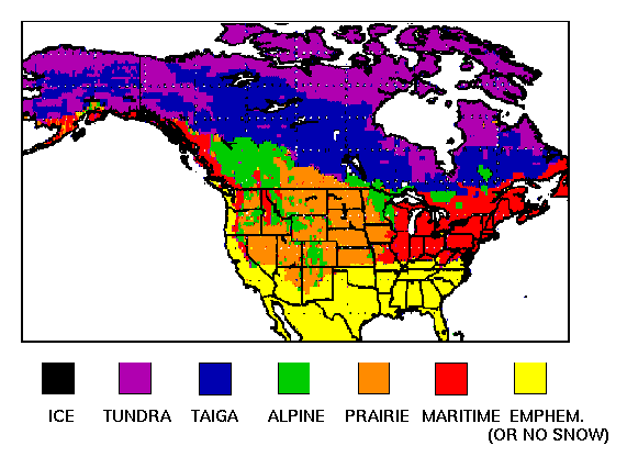
Figure 5. Region-scale snow classes derived from decision-tree model of snow type based on air temperature, wind speed and precipitation. Figure adapted from Sturm et al., (1995).
Snow classes within North America span the range manifested globally according to the climatological classification shown in Figure 5. While we acknowledge the importance of generality in snow and freeze/thaw algorithms, accuracy, or lack thereof, in these measurements may have different impacts in different regions. Thus potential test areas can be ranked according to their representation of regions where snow and freeze/thaw have importance to socio-economic sectors (e.g., water resources, flooding) and large-scale terrestrial ecology (e.g., boreal forest). Critical consideration also includes ease of access by large field parties for making ground truth measurements, ferry time of NASA or other aircraft, and supporting infrastructure, such as weather stations, GIS coverage, etc., which are required to aid interpolation of ground measurements.
Four regions show strong potential
for serving as experiment areas to test algorithms for recovering snow
properties and freeze/thaw timing from flight lines or transects of airborne
measurements:
Field Validation of SAR Algorithms
to Detect Freeze-Thaw States
Since the early 1990's airborne and space-borne radar measurements have shown that changes in radar cross section correlate to changes in forest freeze-thaw state, snow cover wetness and soil moisture; this has been demonstrated with active measurements across the microwave spectral region, from L-band to Ku-band.
Some current ecological models treat the vegetation, soil and snow as a lumped system. Radar measurements accurately detect phase changes in this system provided that time series of radar images are geolocated and have the same viewing geometry [Rignot and Way, 1994; Rignot et al., 1994; Way et al., 1994]. Due to the complexity of scattering and absorption in a system consisting of vegetation, snow and soil, the use of physics-based modeling has been limited. Current algorithms use change detection and threshold classification as primary discriminants. However, the partitioning of freeze-thaw processes between land cover elements constitutes an important issue in hydrological study and will likely become important to ecological modelers as improvements require understanding of partitioning of freeze-thaw over different regions.
Changes at a forest floor in terms of soil moisture, soil freeze thaw and snow properties have been detected using frequencies ranging from L-Band and C-band [Way et al., 1994; Pulliainen et al., 1999] to X-Band [Pulliainen et al., 1994]. Both models and measurements show that higher frequencies have greater sensitivity to volume scattering within tree and vegetation canopy, and snow, while lower frequencies have greater capability to penetrate dry snow and canopy. Radar measurements to investigate the partitioning of freeze-thaw processes will thus likely require more than one frequency and polarization, as well as geolocation of measurements and frequent revisits. Efforts to parse different effects of phase change in land cover components could also possibly benefit from multiple look angles.
Validation of algorithms to separate processes in vegetation, snow and soil is required. These studies will require airborne data collection, and should use test areas with extensive ground measurement sites, such as those recommended above. The use of optical data for snow detection and surface temperature measurement may help validation efforts. Models that can interpolate point measurements of the relevant properties will improve confidence in validation results.
Field Validation of SAR and Radiometer
Algorithms to Measure Snow
Methods to estimate snow properties from SAR measurements have used algorithms based on physics [e.g., Shi and Dozier, submitted], classification trees [Shi and Dozier, 1997], time-series derivatives and thresholding [Baghdadi et al., 1997, Koskinen et al., 1997]. Methods to estimate snow properties from radiometer measurements were tested and evaluated extensively using Nimbus-7 SMMR and DMSP SSM/I data [Chang et al., 1987, Goodison et al., 1990]. Currently, routine SWE estimates over the Canadian prairie are made by using special sensor microwave/imager (SSM/I) data [Goodison and Walker, 1994]. These data have a resolution of about 25 km, which leads to particular considerations in preparing ground-truth maps. Verification of SAR and radiometer algorithms to recover snow cover extent, water equivalent and wetness, thus likely requires different techniques to build maps of snow properties directly comparable to algorithm retrieval. Performance limits to snow detection and measurement are necessary to establish confidence estimates based on terrain, cover of forest and other vegetation. Comparison studies are also required to determine relationships between snow maps derived from different sensors, which will be useful for data assimilation in hydrologic modeling.
Snow Extent.Comparison between SAR estimates of snow cover extent and snow maps derived from optical systems or photography over different snow, land cover types and terrain will allow the determination of the performance of SAR to retrieve snow cover area. Multispectral and hyperspectral optical systems can measure snow covered area as fractional cover per pixel over large areas with high accuracy provided that the snow is optically thick [Rosenthal and Dozier, 1996]. Aerial photography can also measure binary snow extent at high spatial resolutions but with limited spatial coverage.
Snow Water Equivalent. Past research has been limited by comparing image products with point measurements. Spatial data, water equivalent estimated from microwave measurements, must be compared to independently measured or estimated spatial data. Thus field validation of SAR and radiometer estimates of snow water equivalent will require a mix of measurements and modeling to generate independent spatial estimates. Several methods have been developed that could provide spatial snow water equivalent data for comparison to SAR data. Snow water equivalent can be measured along individual flight lines by measuring the attenuation of natural terrestrial gamma radiation by the snow water equivalent [Peck et al., 1980; Carroll, 1987]. Operational airborne gamma survey methods measure the average spatial snow water equivalent along transects 250-300 m wide by several kilometers long, consistent with the baseline spatial resolution identified for this mission. FMCW radar has also shown some promise to measure depths of deep alpine snow along transects (Rosenthal et al., submitted). Recent studies have shown that credible interpolation of snow water equivalent based on terrain and land cover variables can be achieved through geostatistical [Carrol and Cressie, 1996] and decision-tree models [Elder et al., 1998] provided that they are supported by a reasonably dense set of survey measurements. Snow process modeling may also likely be required to interpolate snow physical properties from snow pit, survey, extent and other measurements [Cline et al., 1998].
Snow Surface Wetness. Maps of snow wetness indicate areas that may be contributing to runoff. Like snow water equivalent, ground measurements of snow wetness must be interpolated to generate spatial products for comparison to microwave-derived products. In this case, a distributed physical model of snow processes seems the only likely method [e.g. Davis et al., 1995]. Airborne measurements using absorption spectroscopy have shown some promise for measuring snow surface wetness over areas [Green and Dozier, 1996].
IV. REQUIRED PRE-LAUNCH
TECHNOLOGY INVESTMENTS
FOR THE COLD LAND
PROCESSES MISSION
A technology assessment of the objectives and requirements of the Cold Land Processes Mission identified six major technology challenges for the mission. An investment in technology development in these six areas is necessary to prepare a mission-ready proposal.
1. Higher Orbit Altitude Trade Study. The baseline mission design described above is feasible, but the same objectives could be accomplished with a simpler and less expensive radar by reducing the number of beams and improving the signal-to-noise and ambiguities at the high incidence angles by raising the orbit altitude to 2000 km or higher. A trade study is required to address the increased power requirement vs. fewer beams to achieve the desired coverage:
(b) Higher orbit altitudes require higher transmit power. Since Scansar operation requires fast elevation beam steering, transmit/receive (T/R) modules distributed in elevation are required. Typical maximum power per module at L-band is roughly 100 Watts and at X-band is roughly 10-20 Watts. These limitations impact the number of modules required for the full array and therefore the antenna costs. All of these factors must be carefully evaluated to properly assess the optimal orbit configuration.
The X-band mission can also utilize inflatable antenna technology. There are some additional technical issues, however, associated with the use of inflatable antennas at X-band. With a 10 MHz bandwidth, the inflatable antenna should be able to provide dual-polarization capability with 8 KW of transmit power, although the electronics scanning will be limited to ±30 deg. As already described in (1), the spacing between the elements primarily cause this limitation, which must be large enough to accommodate the polarization feed network. Other technical challenges include proper distribution of the large number of T/R modules (roughly 500 or more) as well as power, control and RF feed networks. Another challenge of the X-band antenna is maintaining global membrane flatness for the very long and narrow structure (12.8m x 0.5m). The framed membrane approach may be considered for this application to maintain flatness of this structure. Framed membrane technology has an identical aperture design as the inflatable membrane antenna however the structure consists of a lightweight composite fold-up planar frame and carpenter tape hinges for pre-loaded deployment. This technology is also currently being developed with a current TRL level of 4. The inflatable membrane antenna has a projected mass density of 2 to 3 kgm-2 and the framed membrane antenna has a projected mass density of approximately 4 to 5 kgm-2.
3. Higher-resolution Mode Trade Study. Higher spatial resolution data may be desired for this study. The spatial resolution for this mission may be achieved in different ways. Higher resolution is possible by giving up swath width to improve ambiguities and to reduce the data rate. The baseline mission is designed for maximum swath coverage. Other system trades can be performed including having multiple radar modes.
4. Dual-frequency, Shared Aperture Trade-off Study. The baseline mission design assumes independent platforms for L-band and X-band. Recent advances have been made in the area of dual-frequency, shared aperture antennas, and miniaturized, power efficient electronics, which could enable a dual-frequency platform. A prototype L-band and X-band shared aperture antenna subarray has been demonstrated with good performance. The design is currently being implemented as a larger array on membrane for use with inflatable structures. Technical challenges of this approach include implementing dual polarization and wide scanning as well as distribution of the large number of T/R modules required for the high power requirement. These are similar challenges as with the other antenna technologies previously described, however they become more difficult to solve due to the shared aperture architecture. The current TRL is 3 and this technology is not anticipated to be ready for future missions until 2005.
5. Formation Flying Technology Development Support. To satisfy the requirement for simultaneous dual-frequency SAR measurements, the dual-spacecraft option must be capable of formation flying as well as repeat-pass interferometry for change detection. This requirement imposes stringent control and knowledge of the platform orbit. If we assume similar performance requirements as LightSAR, then the pointing control in azimuth and elevation are 0.015 deg and 0.05 deg respectively at X-band, worst case. The pointing knowledge is 0.01 degrees at X-band. Startrackers can provide pointing knowledge of 0.0008 degrees in all axes. Further studies of the orbit accuracy and formation flying requirements are required. Furthermore, the autonomous formation flying spacecraft technology needs to be developed and demonstrated. There are three planned missions that will demonstrate formation flying. These include (1) NMP EO-1, which will fly in formation with Landsat 7 in early 2000, (2) Jason-1, which will fly in formation with Topex/Poseidon in late 2000, and (3) Cloudsat, which will fly in formation with Pacasso in 2003. There is also a new technology program being initiated by NASA Code Y to mature platform technologies. Autonomous formation flying must be emphasized as an important technology thrust in this platform technology program.
6. Proposal to
the IIP Program. A detailed mission design study and technology
development and demonstration plan should be proposed to the IIP program.
This should include the trade studies described above in addition to demonstration
and calibration of the 8-beam Scansar mode using an airborne test bed (possibly
a modification of Airsar with active phased-array capability). Field campaigns
using Airsar would also be useful for algorithm validation of simultaneous
polarimetric and interferometric data collection. In addition, the polarimetric
mode of LightSAR should be used to improve the existing algorithms.
Options 3 and 4:
Radiometer Technology for Snow Measurements
For Options 3 and 4, the challenges to technology mainly centered on the need of a large antenna subsystem to achieve the required spatial resolution. Investments in technology development supporting the following areas are necessary to prepare a mission-ready proposal.
1. Large antenna and aperture synthesis trade study. The spatial resolution of radiometer is basically limited by the size of the antenna. To achieve the spatial resolution of 1-5 km, a large antenna subsystem is required. There are two distinct approaches: (1) large real aperture system and (2) thin array aperture synthesis. For the real aperture system, an inflatable antenna could be a good candidate. An inflatable antenna has been tested in space for communication applications. For radiometer application, the rigidity requirement is much more stringent. It is necessary to test whether the surface roughness tolerance of 1/8 wavelength can be achieved. Solid aperture and mesh antenna systems (about 5 meter) will also be studied. Its deployment mechanism also will be studied. For an aperture synthesis system, the 1 D or 2 D system should be evaluated for this application. Then evaluation of the available technology of building a two-frequency dual polarization thin array system should be conducted.
2. Digital correlator and low noise amplifier development study. For synthetic aperture approaches, high speed and low power digital correlators and low loss integrated receivers must be developed. A high spatial resolution 2D aperture synthesis system requires large number of digital correlators and low noise amplifiers. The weight and power become a major factor in the system design. It is pertinent to have efficient hardware that conserves spacecraft power. Ideally, the power dissipation of each low noise amplifier will be reduced to less than 100 mW. Also the power consumption of each integrated radiometer modules will be reduced to less than 2 W. The weight, structure and packaging of this large system will require further study.
3. Calibration system design study. Calibration for a radiometer system is critical. It is necessary to determine what calibration procedures are needed to achieve the NEDT better than 0.5 K. Particularly, in the 2 D aperture synthesis system, there will be hundreds of receivers in the entire system.
4. Metrology study. Due to the short wavelength, the overall flatness of the antenna surface has to be better than 1 mm. Optical metrology should be explored to achieve this demanding requirement.
5. Antenna element design/fabrication. For the 2 D aperture synthesis antenna, many array elements are needed for a 37 GHz system. Reproducibility of each array element becomes critical. A prototype array element must be designed and fabricated. In addition, research on how to package dual polarization and dual frequency in a 2 D thin array configuration should be conducted.
Implementation of the Cold Land Processes Mission will require a minimum of six years, with a launch in early 2005. Critical milestones in an aggressive implementation schedule include:
a) Early support of low-cost paper studies by NASA Land Surface Hydrology Program (LSHP), before 2001 LSHP budget increase is approved.
c) First field/airborne campaign completed by spring, 2001
d) Sufficient science and technology work completed to submit mission-ready proposal by January 2002.
e) Selection of the Cold Land Processes Mission by July 2002
f) 30-month development schedule for construction of sensors, to be completed by December 2004.
| Year | Date | Task |
| 1999 | May | Begin trade studies to refine science requirements for the mission (no additional support required). |
| 1999 | Nov | Irvine Report Released |
| 1999 | Nov | Begin planning 2001 field/airborne campaigns, particularly aircraft requirements (~12-18 month lead time required to schedule aircraft). |
| 1999 | Nov | LSHP releases A.O. for paper studies, field/airborne campaign, technology studies, all pending final 2000 budget approval. |
| 1999 | Nov | Request 2001 NASA budget allocation to Land Surface Hydrology Program to support pre-selection science and technology studies. |
| 2000 | Jan | Tentative notice of NASA intent to include increase in LSHP 2001 budget. |
| 2000 | Feb | A.O. Proposals Due, review process carried out. |
| 2000 | Mar | Finalize aircraft schedule for first field/airborne campaign in Spring, 2001 |
| 2000 | Oct | Complete initial trade studies and first round of (low-cost) paper studies |
| 2000 | Oct | NASA LSHP 2001 budget increase approved |
| 2001 | Jan | Begin mission data processing pathfinder, possibly using Envisat data |
| 2001 | Mar | First field/airborne campaign. |
| 2001 | Oct | Preliminary results from first campaign |
| 2001-
2002 |
Oct-
May |
Second field/airborne campaign |
| 2002 | Jan | Submit "mission-ready" proposal to NASA based on work to date. |
| 2002 | July | Notice of mission selection |
| 2002-
2004 |
July-
Dec |
Sensor Construction |
| 2003 | Ramp up ground segment, finalize algorithms | |
| 2005 | Launch |
VI. REFERENCES
Alasalmi, H., Praks, J., Arslan, A.N., Koskinen, J., Hallikainen, M., and Hyyppä, Investigation of snow and forest properties using airborne SAR data, Proceedings of the 2nd International Workshop on Retrieval of Bio- & Geo-physical Parameters from SAR Data for Land Applications, 21-33 October 1998, ESTEC, Noordwijk, The Netherlands, ESA SP-441, 495-502.
Allbright, T., Painter, T., Shi, J.C., and J. Dozier, Classification of surface types using SIR-C/X-SAR, Mount Everest area, Tibet, Journal of Geophysical Research, 103(E11), 25, 823-25, 837, 1998.
Baghdadi, N., Y. Gauthier and M. Bernier, Capability of multitemporal ERS-1 SAR data for wet-snow mapping, Remote Sensing of Environment, 60(2):174-186, 1997.
Betts, A.K., Viterbo, P., Beljaars, A., Pan, H., Hong, S., Goulden, M., and S. Wofsy, Evaluation of the land-surface interaction in the ECMWF and NCEP/NCAR reanalysis models over grassland (FIFE) and boreal forest (BOREAS), Journal Geophysical Research (in press), 1998.
Blöschl, G., Scale and Scaling in Hydrology, Wiener Mitteilungen, Band 132, Technische Universität Wien, Institut für Hydraulik, Gewässerkunde und Wasserwirtschaft, Wien, 1996.
Carroll, T., Operational airborne measurements of snow water equivalent and soil moisture using terrestrial gamma radiation in the United States, in Large Scale Effects of Seasonal Snow Cover, IAHS Publ. 166, 213-223, 1987.
Carroll, S.S., Cressie, N., Comparison of geostatistical methodologies used to estimate snow water equivalent, Water Resources Bulletin, 32(2): 267-278, 1996.
Chang, A.T.C., J.L. Foster, D.K. Hall, B.E. Goodison, A.E. Walker and J.R. Metcalfe, Snow parameters derived from microwave measurements during the BOREAS winter field campaign, Journal of Geophysical Research, 102(D24): 29,429-29,444, 1997..
Cline, D., Bales, R., and J. Dozier, Estimating the spatial distribution of snow in mountain basins using remote sensing and energy balance modeling, Water Resources Research, 34(5), 1275-1285, 1998a.
Cline, D., Elder, K., and R. Bales, Scale effects in a distributed snow water equivalence and snowmelt model for mountain basins, Hydrological Processes, 12, 1527-1536, 1998b.
Cline, D., and T. Carroll, Inference of snow cover beneath obscuring clouds using optical remote sensing and a distributed snow energy and mass balance model, Journal of Geophysical Research - Atmospheres (in press), 1999.
Cline, D., T. Carroll, and A. Rost (PIs), "Operational Assimilation of Satellite, Airborne, Surface, and Mesoscale Atmospheric Model Data to Estimate Snow Water Equivalence over Large Regions", NASA Earth Science Enterprise, Land Surface Hydrology Program (LSHP-2-0016), 1998.
Davis, R., J. McKenzie, and R. Jordan, Distributed snow process modeling: an image segmentation approach, Hydrologic Processes, 9, 865-875, 1995.
Frolking, S., Goulden, M., Wofsy, S., Fan, S., Sutton, D., Munger, J, Bassas, A., Daube, B., Crill, P., Aber, J., Band, L., Wang, X., Savage, K., Moore, T., and R. Harriss, Modelling temporal variability in the carbon balance of a spruce/moss boreal forest, Global Change Biol. 2, 343-366, 1996.
Elder, K., Rosenthal, W., Davis, R.E., Estimating the spatial distribution of snow water equivalence in a montane watershed, Hydrological Processes, 12(10-11): 1793-1808, 1998.
Green, R. O. and J. Dozier, Retrieval of surface snow grain size and melt water from AVIRIS spectra, In, Summaries of the 6th Annual JPL Airborne Earth Science Workshop, Ed. Robert O. Green, JPL Publication 96-4, Vol. I: 127-134, 1996.
Koskinen, J.T., J.T. Pulliainen and M.T. Hallikainen, Use of ERS-1 SAR data in snow melt monitoring, IEEE Transactions on Geoscience and Remote Sensing, 35(3): 601-610, 1997.
Hinzman, L., Kane, D., Benson, C., and K. Everett, Energy balance and hydrological processes in an arctic watershed, in J.F. Reynolds and J.D. Tenhunen (Eds.) Ecological Studies, Vol. 120, Springer-Verlag, Berlin, 131-154, 1996.
Houghton, J.T. et al. (Eds.), Climate Change 1995: The Science of Climate Change, Report of the Intergovernmental Panel on Climate Change, Cambridge University Press, Cambridge, 1996.
Kane, D., and E. Chacho, Frozen ground effects on infiltration and runoff, in W. Ryan and D. Crissman (Eds.) Cold Regions Hydrology and Hydraulics, Technical Council on Cold Regions Engineering Monograph, American Society of Civil Engineers, New York, 259-300, 1990.
Peck, E., Carroll, T., and S.C. Vandermark, Operational aerial snow surveying in the United States, Hydrological Sciences Bulletin, 25, 51-62, 1980.
Pulliainen, J.T., K. Heiska, J. Hyyppa\: and M.T. Hallikainen, Backscattering properties of boreal forests at the C- and X-bands, IEEE Transactions on Geoscience and Remote Sensing, 32(5):1041-1050, 1994.
Pulliainen, P.J. Mikkela\: and M.T. Hallikainen, 1996, Seasonal dynamics of C-band backscatter of boreal forests with applications to biomass and soil moisture estimation, IEEE Transactions on Geoscience and Remote Sensing, 34(3):758-770.
Pulliainen, L. Kurvonen and M.T. Hallikainen, 1999, Multitemporal behavior of L- and C-band SAR observations of boreal forests, IEEE Transactions on Geoscience and Remote Sensing, 37(2):927-937.
Rango, A., Spaceborne remote sensing for snow hydrology applications, Hydrological Sciences Journal, 41(4), 477-494, 1996.
Rignot, E. and J.B. Way, 1994, Monitoring freeze-thaw cycles along north-south Alaskan transects using ERS-1 SAR, Remote Sensing of Environment, 49:131-137.
Rignot, E., J.B. Way, K. McDonald, L. Viereck, C. Wiliams, P. Adams, C. Payne, W. Wood and J. Shi, 1994, Monitoring of environmental conditions in taiga forests using ERS-1 SAR, Remote Sensing of Environment, 49:145-154.
Robinson, D., Dewey, K., and R. Heim, Global snow cover monitoring: An update, Bull. American Meteorological Society 74, 1689-1696, 1993.
Rosenthal, W., and J. Dozier, Automated mapping of montane snow cover from the Landsat Thematic Mapper, Water Resources Research, 32(1), 115-130, 1996.
Rosenthal, W., R, Yankielun and R. E. Davis, Alpine snow depth measurements from aerial FM-CW radar, Cold Regions Sci. Tech. (submitted - 1999).
Rott, H., and T. Nagler, Capabilities of ERS-1 SAR for snow and glacier monitoring in alpine areas, Proceedings, Second ERS-1 Symposium, 1-6, 1993.
Rott, H., C. Mätzler, D. Strohl, S. Bruzzi, and K.B. Lenhart, Study on SAR land applications for snow and glacier monitoring, Technical Report 6618/85/F/FL (SC), European Space Agency, 1988.
Running, S.W., Kimball, J., Keyser, A., Way, J.B., McDonald, K.C., Frolking, S., and R. Zimmerman, Radar remote sensing proposed for monitoring freeze/thaw transitions in boreal regions, EOS, (in press), 1999.
Shi, J.C., and J. Dozier, Measurements of snow- and glacier-covered areas with single polarization SAR, Annals of Glaciology, 17, 72-76, 1993.
___________________, Inferring snow wetness using C-band data from SIR-C?s polarimetric synthetic aperture radar, IEEE Transactions on Geoscience and Remote Sensing, 33(4), 905-914, 1995.
___________________, Estimation of snow water equivalence using SISR-C/X-SAR, Proceedings IGARRS ?96, IEEE No. 96Ch35875, 2002-2004, 1996.
___________________, Mapping seasonal snow with SIR-C/X-SAR in mountainous areas, Remote Sensing of Environment, 59, 294-307, 1997.
_________________, Estimation of snow water equivalence using
SIR-C/X-SAR, IEEE Transactions on Geoscience and Remote Sensing, submitted, 1999.
Shi, J.C., J. Dozier, and H. Rott, Snow mapping in alpine regions with synthetic aperture radar, IEEE Transactions on Geoscience and Remote Sensing, 32(1), 152-158, 1994.
Shi, J.C., S. Hensley, and J. Dozier, Mapping snow cover with repeat pass synthetic aperture radar, Proceedings IGARSS ?97, IEEE No. 97CH36042, 628-630, 1997.
Shi, J.C., T. Painter, and J. Dozier, Estimation of snow surface albedo using Landsat Thematic Mapper, Proceedings IGARRS ?96, IEEE No. 96CH35875, 2249-2251, 1996.
Sturm, M., J. Holmgren, G.E. Liston, Seasonal snow cover classification system for local to global applications, J. Climate, 8(5)pt.2, 1261-1283, May 1995.
U.S. Dept. of Commerce, Service Assessment and Hydraulic Analysis, Red River of the North 1997 Floods, National Weather Service, NOAA,1998b.
Washburn, A., Geocryology, Edward Arnold, 1979.
Way, J., Paris, J., Kasischke, E., Slaughter, C., Viereck, L., Christensen, N., Dobson, M., Ulaby, F., Richards, J., Milne, A., Sieber, A., Ahern, F., Simonett, D., Hoffer, R., Imhoff, M., and J. Weber, The effect of changing environmental conditions on microwave signatures of forest ecosystems: preliminary results of the March 1988 Alaskan aircraft SAR experiment, International Journal of Remote Sensing, 11(7), 1119-1144, 1990.
Way, J.B., E.J.M. Rignot, K.C. McDonald, R. Oren, R. Kwok, G. Bonan, M.C. Dobson, L.A. Viereck, J.E. Roth, Evaluating the type and state of Alaska taiga forest with imaging radar for use in ecosystem models, IEEE Transactions on Geosceince and Remote Sensing, 32(2); 353-369, 1994.
Way, J.B., Zimmerman, R., Rignot, E., McDonald, K., and Oren, Winter and spring thaw as observed with imaging radar at BOREAS, J. Geophysical Research 102(29), 673-29, 684, 1997.
Williams, P., and Smith, M., The Frozen Earth: Fundamentals of Geocryology, Cambridge University Press, Cambridge, 1989.
Wilson, L.L., Tsang, L., Hwang, J.-N., and Chen, C.-T., Mapping snow water equivalent by combining a spatially distributed snow hydrology model with passive microwave remote-sensing data, IEEE Transactions on Geoscience and Remote Sensing, 37(2), 690-703, 1999.
Yang, Z.L., Dickinson, R.E., Robock, A., and K. Vinnikov, Validation of the snow submodel of the Biosphere-Atmosphere Transfer Scheme with Russian snow cover and meteorological observational data, Journal of Climate, 10(3), 33-53,1997.
Zhang, T., Osterkamp,
T., and K. Stamnes, Effects of climate on the active layer and permafrost
on the North Slope of Alaska, U.S.A.,
Permafrost Periglacial Processes
8(1), 45-67, 1997.