|
NOHRSC Technology >
NOHRSC GIS Applications > IHABBS
Integrated Hydrologic Automated Basin Boundary System
(IHABBS)
An Overview
The Integrated Hydrologic Automated Basin Boundary System, or IHABBS, provides National Weather Service hydrologists with tools for automatically delineating, editing, displaying, querying, and managing hydrologic basin boundaries. It was developed for use in an X-Motif environment on HP workstations, and it requires access to an Informix database that is created and populated upon installation.

Figure 1: A somewhat shrunken version of the IHABBS initial main window, with the RFC centered in the display area.
How IHABBS works:
Basin boundaries are edited, displayed, and managed with customized tools that are similar to those found in geographic information systems. The primary task of IHABBS is to determine the precise geometry, topology, and area of any basin delineated on the basis of a user-selected basin outlet (discharge point). Each basin is defined as the region drained by the basin outlet, and this region is derived from information provided by a flow direction grid. This discharge point may be selected by clicking a mouse on the display or by entering numerical geodetic (longitude and latitude) coordinates (see Figure 2). The geometry of resulting basins is stored in both raster and vector formats. Topology includes information regarding a basin's relationship to other basins (whether it contains or is contained by another basin, and which basin(s) are upstream or downstream of it).
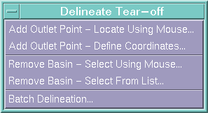
Figure 2: The delineation options menu
IHABBS data sets are projected into a geodetic (longitude and latitude) coordinate system using the WGS 84 datum, which is equivalent to the NAD 83 datum. All calculations in IHABBS are performed using geodetic coordinates. IHABBS automatically compensates for the curvature of the Earth by employing geodetic calculations for computing distance and area on an ellipsoidal (rather than spherical or planar) surface.
The automated delineation process
The following steps describe the delineation process. User-selected options allow for the omission of steps 1 and 3; in other words, IHABBS assumes that the user would like to choose a point on a river or at least along a path of high accumulation, but the user may override these default assumptions to choose any point at all on the flow direction grid.
- Snap the discharge point from the selected location to the nearest stream.
- Quality control the snapped discharge point: a) Make sure that the point is within the RFC, b) Make sure that the point is not within a flat area, and c) Make sure that the point is not in a non- contributing areai
- Shift the snapped discharge point to the most logical local coordinate by: a) Identifying the grid cell to which the snapped discharge point flows, and b) Identifying the flow accumulation of that cell, c) Computing the inverse ratio between the snapped to discharge point flow accumulation with flow accumulation of the cell to which it flows, and d) Shifting the discharge point if the inverse ratio exceeds the ACCUMRATIO value in the IHABBS configuration file.
- Determine if the snapped/shifted discharge point is within another basin.
- Make sure that the snapped/shifted discharge point does not flow into a non-contributing area.
- Assign the flow direction grid at the discharge point to the new basin.
- Recursively identify all cells flowing to the discharge point and assigns them to the new basin. Any of those cells belonging to another basin (other that the within basin mentioned in [4] above) are ignored. If delineating within a basin (see [4] above) the limits of the new basin are constrained by the limits of the within basin.
- Flow direction cells marked as non-contributing area are ignored if the basin is not attributed as including non-contributing area. As a consequence, any cell flowing into the non-contributing area are also ignored.
- If a rain-on-reservoir basin is defined for the new discharge point, any flow direction cell: a) at or less than the rain-on-reservoir basin elevation flowing directly to the discharge point through already defined rain-on-reservoir cells are assigned to the rain-on-reservoir basin or b) at or less than the rain-on-reservoir basin elevation adjacent to already defined rain-on-reservoir cells. Note : The basin in which the rain-on-reservoir is located is referred to as the parent basin. The requested elevation of the rain-on-reservoir may not exceed the elevation of the parent basin.
- If edited areas are encountered in the within basin and they flow to the new basin they are assigned to the new basin as non-edited.
- Vectorize the new basin by tracing the flow direction cells assigned to the new basin. The first vertex of the basin is located at its discharge point. Basins are vectorized in a clockwise direction.
- Compute basin attributes.
- Smooth vector basin boundaries by creating 45 degree polygon segments where the raster basin delineation indicates the existence of corners.
- If the new basin is defined within an existing basin the remainder of the existing basin is revectorized WITHOUT reperforming steps 1-10.
- Recompute attributes for the within basin.
- Smooth vector basin boundaries.
The result of a basin delineation is a single basin in both vector (Figure 3) and raster (Figure 4) form. This basin may be within another basin, and it may also enclose another basin within it.
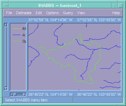
Figure 3: The resulting basin in its vector form
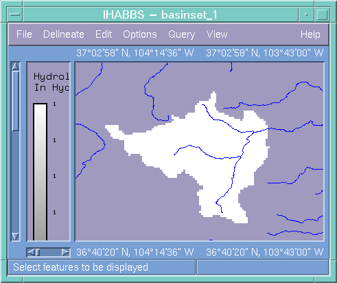
Figure 4: The resulting basin in its raster form
Once basins have been generated, users may interactively edit the resulting basins within IHABBS. Additionally, prior to delineating basins the user has the ability to define rain-on-reservoir basins and non-contributing areas. While IHABBS was designed primarilly as an interactive GIS application, the user may automatically delineate several basins at once by batch-delineating the basins above basin discharge point coordinates recorded in an ASCII file.
IHABBS Data:
The IHABBS software is delivered with several GIS data sets that are required for the delineation process, as well as several data sets that provide ancillary geospatial information to the user. Finally, there are the data sets generated by IHABBS. All of these data sets can be displayed (Figure 3).
These data sets can be categorized as either Raster, Vector, or Point data. The Opened Flow Directions and Flow Accumulations raster data sets and the All Rivers vector data set are required by the delineation process, and they may also be viewed by the user.
Other raster data sets that are provided for the user are Elevations, Slopes, and Aspects. Other vector data sets provided for viewing by the user are Lakes and Reservoirs, RFC Boundaries, State Boundaries, Reference NWS Basins, County Warning Areas, County Boundaries, and HUC Boundaries.
Data that are generated by IHABBS and which can be viewed include a raster version of Opened Basins, a vector version of Opened Basins, and the point data indicating the Opened Basin Outlets.
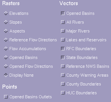
Figure 5: IHABBS provides or generates all of these raster, vector, and point data sets.
While IHABBS was delivered to the RFCs with 15-arc second flow direction and accumulation grids, it should be noted that IHABBS, like every other NOHRSC program, is scale independent. In other words, even though 15-arc second data was delivered, IHABBS can operate on data of any resolution.
NOHRSC preprocessing of IHABBS data
The flow direction and accumulation grids are derived at NOHRSC on the basis of 15 arc-second digital elevation raster data and vector data representing the presence and flow direction of rivers and streams (Figure 6).
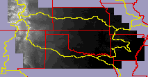
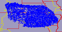
Figure 6: The two data sets from which IHABBS flow direction and accumulation data are derived at NOHRSC are a mosaiced and resampled DEM and RF1 rivers cut and edited from a national coverage
The drainage controlled flow direction grid is constructed for each RFC as follows:
- Ingest, resample, and mosaic, USGS 1 degree sheets of 3 arc-second DEM data sets to a 15 arc-second DEM grid using a smoothing convolution filter,
- Fill spurious depressions in the 15 arc-second DEM,
- Generate a raw flow direction grid using the D-8 algorithm,
- Route lake and reservoirs to their outlets define either by rivers and streams or by the lowest water edge elevation flowing away from the lake or reservoir,
- Route rivers and streams from their headwaters to their tail waters. Route cells immediately adjacent to rivers and streams into the rivers and streams,
- Route flat areas to intersecting streams or the nearest routed cell, and
- Generate an upstream flow accumulation grid from the flow direction grid.
The flow direction grid is the principal data set employed by the IHABBS basin delineation algorithm. After having used the RF1 and flow accumulation data sets to adjust an operator defined discharge point location, IHABBS examines all of the possible upstream flow paths leading to the basin outlet. The assignment of flow direction cells to a given basin proceeds until a) a physiographic divide between a neighboring basin is encountered, b) a previously delineated upstream basin is encountered, or c) an operator defined noncontributing area is encountered.
The flow direction grid indicates, for each 15 arc-second cell, one of eight generalized directions in which surface water may flow (N, S, E, W, NE, NW, SE, SW). The cell may also be 'flat'; such cells are rare and usually indicate points where surface water disappears underground. The result of the delineation process is a spanning tree which links each grid cell in the basin with the basin's discharge point. The flow path from each grid cell in the basin to the basin's discharge point is a) unique and b) does not cross the flow path of any other cell in the basin. Except in the event of dangling streams, no two adjacent flow direction cells are allowed to mirror one another.
The result of the delineation process is a spanning tree which links each grid cell in the basin with the basin's discharge point. The flow path from each grid cell in the basin to the basin's discharge point is a) unique and b) does not cross the flow path of any other cell in the basin.
The rivers and streams layer is derived from the EPA River Reach version 1 file (RF1), which has been tested and corrected for hydrographic integrity and edited to ensure registration with the DEM. Since neither the USGS DEM nor the EPA RF1 data extended significantly into Canada, it was necessary to find alternative sources for these data and merge them with the US data. DEM data were provided by Geomantics Canada in two different formats. Most of the requested data was
provided at a 3 arc-second resolution in the DTED format, but much of this data proved to be corrupted, particularly in British Columbia. Fortunately, more recently generated data in the 'CDED' format was available to replace problem areas in the DTED. Nevertheless, some problems remained, particularly on the borders between sheets, and between the Canadian and US data. Smoothing and manual editing reduced the severity of these problems, resulting in a hydrologically useful DEM that was used to generate satisfactory flow direction data in these areas.
River data gleaned from the Arc/Info Digital Chart of the World for the relevant Canadian regions was merged with the previously processed RF1 data. Unfortunately, certain attributes were missing from the Canadian river reaches (e.g., name), and the data were edited to ensure proper downstream flow (as determined by vertex ordering). In addition, these data were somewhat less detailed than the RF1 data, as reflected by an absense of streams. However, this was not a major problem as the DEM was sufficiently reliable to provide proper flow.
|


