|
|
 |
National Weather Service |
 |
|
| National Operational Hydrologic Remote Sensing Center |
| Home | News | Organization |
|
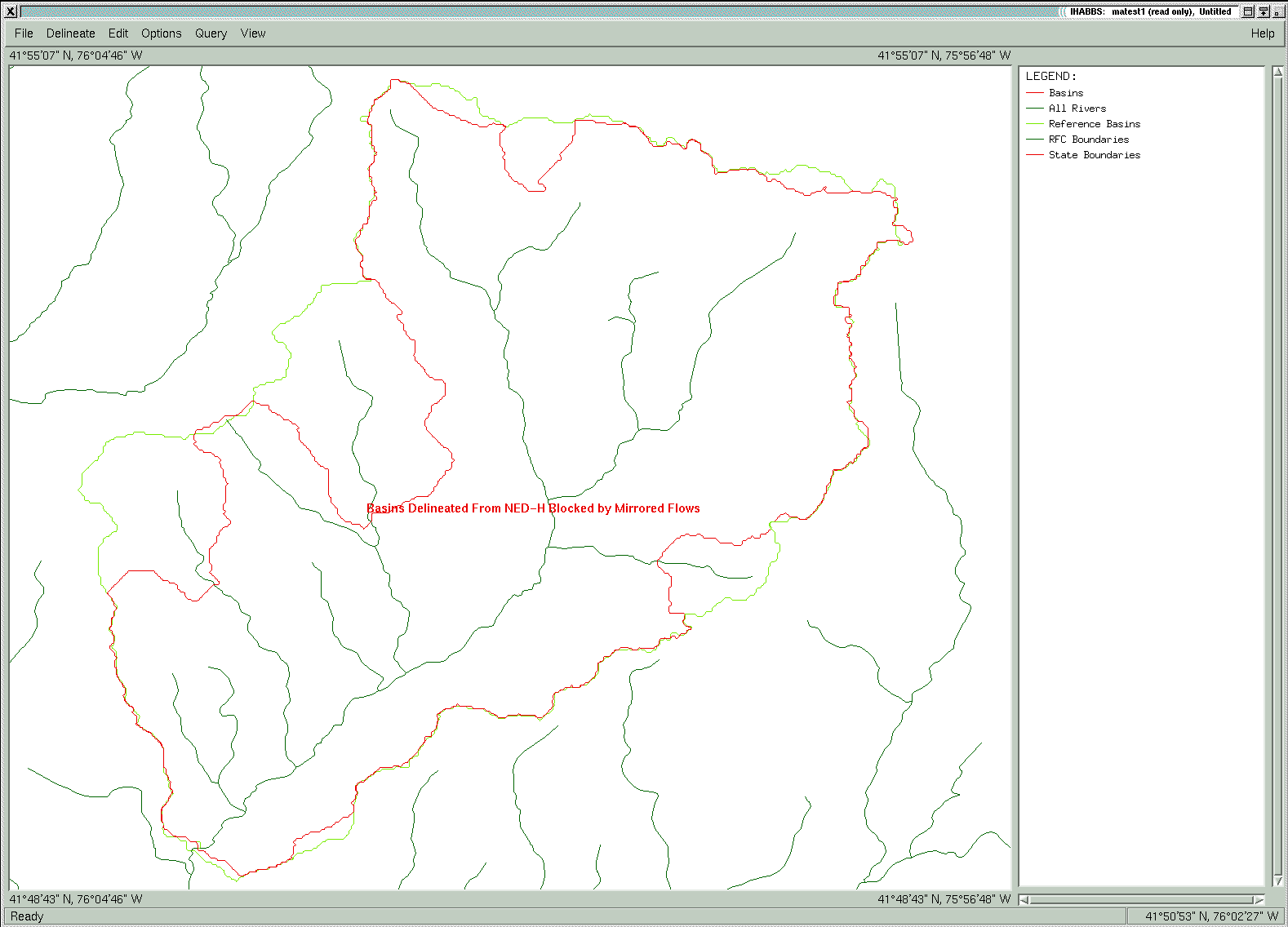
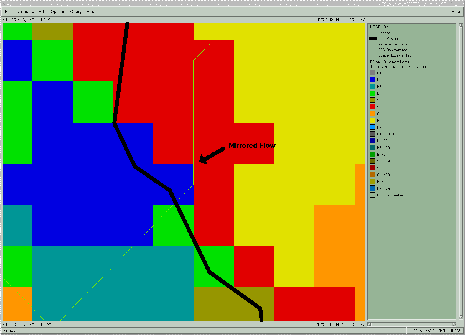
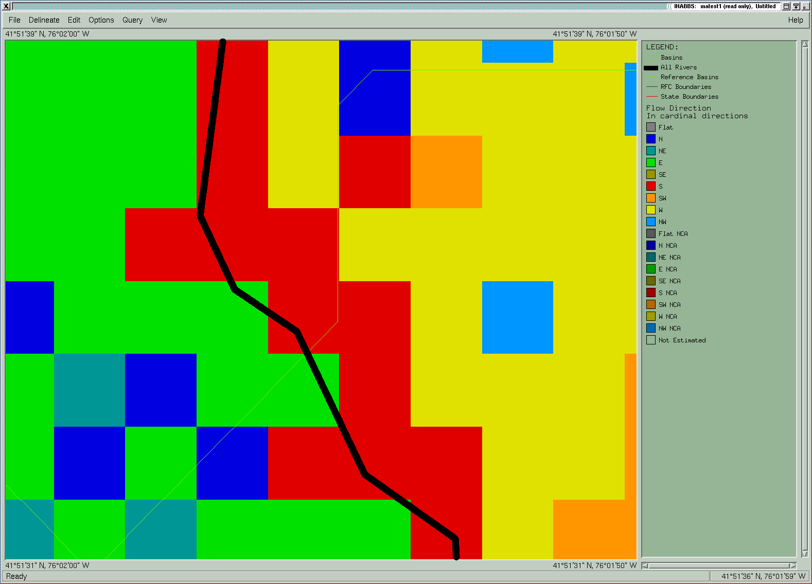
NOHRSC Technology > NOHRSC GIS Applications > Miscellaneous NOHRSC Test of USGS NED-H DataThe Integrated Hydrologic Advanced Basin Boundary System (IHABBS) was created at the National Operational Hydrologic Remote Sensing Center (NOHRSC) in order to answer the need for accurate basin boundaries for use in the National Weather Service River Forecast Centers. IHABBS is used to delineate basins for the United States using a flow direction grid at a resolution of 15 arc seconds (each cell is about .5 km on a side). The total size of these data is about 200 megabytes for the coterminous US. Recently, flow direction grids at a resolution of 1 arc second (30m -- 44 gigabytes for the coterminous US) have been made available through a joint effort by the US Geological Survey (USGS) and the National Severe Storms Laboratory (NSSL) of the National Weather Service (NWS). The NOHRSC conducted a test to evaluate the ability of the IHABBS to use the high resolution (one arc second) flow direction data created for the National Elevation Dataset Hydrologic Derivatives (NED-H). The initial stage of this test was to acquire flow direction data created as a byproduct of the basin delineation process being done through the Areal Mean Basin Estimated Rainfall (AMBER) initiative of the NSSL in cooperation with the USGS NED-H program. For this test a large area within the Mid Atlantic River Forecast Region (MARFC) was selected so that basins could be delineated that would be comparable in size to the basins being produced through IHABBS now using the 15 arc second flow direction data that has been processed through the NOHRSC GISRS system. The first step for this process was to acquire and mosaic the flow direction grids acquired for 44 8-digit HUC's, just over half the area of MARFC. These data were then reclassified so the 8 cardinal direction flow direction classification would match the classification used in IHABBS flow direction grids and reprojected to geographic coordinants to work with IHABBS, which requires that data be in geographic coordinates. Concurrently, modifications were made to ensure that IHABBS could work with the new data. For IHABBS to process a flow direction grid to make basins, it requires a coherent flow direction grid. This is a grid where all data can flow freely across the surface. This means that if a basin outlet point or seed point such as a gauge station were placed on the grid, that a basin could be delineated where all pixels route water from one pixel to another eventually to the seed point. If this seed point is located on a river reach, the basin boundary should extend beyond the furthest upstream point of all reaches that flow to that point. When the NED-H flow direction grids were reprojected and brought into IHABBS they did not satisfy the criteria for a coherent flow direction grid. The main problem was the presence of many mirrored flows: a condition where two pixels both indicate that they flow into each other. This condition was caused by the resampling of the data when it was reprojected from the Albers projection used by the NSSL to the geographic coordinates required by IHABBS. This nearest neighbor resampling caused pixels to be repositioned such that they no longer made a coherent flow direction grid. The problem with these mirrored flows is that they cannot be correctly routed to the next downstream pixel . This causes a blockage in the flow direction grid. The next problem lies more in the placement of seed points and the need for an ability to snap to flow accumulations rather than an inherent problem with the data. The areas where flow accumulates on the NED-H flow direction grids are not coincident with the USGS National Hydrography Dateset (NHD) reaches that were delivered along with the NED-H. Therefore, a seed point placed on an NHD stream will not necessarily lead to a delineation which extends all the way up the reach. Rather the areas of high accumulation must be identified for seed point placement. Since the categorical flow direction grid could not survive the resampling caused by the reprojection into geographic coordinates, the next step was to process the elevation data that came with the NED-H through the IHABBS flow direction grid process (see description here) in order to determine the viability of IHABBS for use at a 1 arc second resolution. For this, the original NED (National Elevation Dataset) and NHD (National Hydrography Dataset) from a single 8 digit HUC in the MARFC were processed through IHABBS in order to create a coherent flow direction grid. From this IHABBS-processed grid, test basins were then delineated. What can be seen in figure 1 is the difference between basins delineated using IHABBS flow directions (the green line) and those that have been created using NED-H flow direction grids (the red line). This difference shows that the flow direction grid that was projected into geographic coordinates is fatally flawed for use in IHABBS. What can be seen in figures 2 and 3 is the difference between the reprojected NED-H flow directions(figure 2)and the flow direction grids created by processing the NED through IHABBS (figure 3). The first thing to notice in the reprojected NED-H flow directions is the presence of a mirrored flow which blocks any water from further upstream the shown reach from reaching the basin outlet. The next thing to notice is the lack of alignment between the reach and the flow direction grid. In comparison, the IHABBS flow direction grid created from the NED contains no mirrored flows and shows perfect alignment with the reach. This alignment of the river reaches with the flow directions ensures that every basin delineated with a seed point on the reach will be ensured to create a basin that will completely encompass all upstream reaches. In summary, the flow direction data that came out of the NED-H was found to not be adequate for use in IHABBS as it is currently configured. In order for IHABBS to be able to use the NED-H flow direction grids, it would need to be reconfigured to work with data in the same projection as the original data. In addition, the NED-H flow direction data did not match up with the companion streams coverage. This made it impossible to solely use seed points that have been registered to the streams dataset for basin delineation. For future use of these high resolution data it would be required to either reconfigure IHABBS to work in the same projection as the data, or to process the data through IHABBS beginning with the elevation data and the streams data.
Figure 1. Comparison of IHABBS basins created using NED-H flow directions with IHABBS processed flow directions.
Figure 2. Mirrored Flow evident in NED-H flow directions where North flowing pixel (blue) flows into South flowing pixel (red).
Figure 3. IHABBS processed flow directions.
For further information on this exercise or on IHABBS, please call Anders Nilsson at (952)-368-2517 or email at
|
||||||||
![[anders DOT nilsson AT noaa DOT gov]](/directory/contact/anders_nilsson.png)
