DeHavilland Twin Otter (DHC-6)

The DeHavilland Twin Otter (DHC-6) is a highly maneuverable, versatile aircraft which can be flown slowly (80-160 knots/150-300 km/hr) and in tight circles. The Twin Otter is a high-winged, unpressurized, twin-engine turboprop aircraft equipped with color weather radar, radar altimeter, dual GPS/Loran-C navigation systems with scientific data drops, and camera ports in the nose and belly areas. A standard flight crew consists of two NOAA pilots. In support of NOAA or NOAA-related missions, this platform has conducted low-level slow speed aerial surveys of marine mammals, aerial video surveys of coastal erosion, various remote sensing missions, atmospheric air chemistry sampling, and atmospheric eddy flux and concentration gradient assessments.
Standard Aircraft Specifications
|
Type:
|
Engines De Havilland DHC-6 Twin Otter, Series 300
United Aircraft of Canada Limited PT6A-27
(turboprop)
|
|
Crew:
|
2 Pilots + 6 Scientists
|
|
Ceiling:
|
12,500 feet (without supplemental cabin oxygen)
25,000 feet(with supplemental cabin oxygen)
|
|
Rate of Climb:
|
1600 feet/minute
|
|
Operational Airspeeds:
|
80-160 knots
Electrical Two 28 VDC 250 ampere starter-generators
|
|
Scientific Power:
|
3 KVA of 115 VAC, 60 Hz and 70 A of 28 VDC
|
|
Maximum Gross Weight:
|
12,500 lbs.
|
|
Empty Weight:
|
8,100 lbs.
|
|
Useful Load:
|
4,400 lbs. (fuel, personnel, cargo)
|
|
Fuel Load:
|
2,500 lbs. with additional 1,000 lbs. in optional cabin auxiliary tank
(Note: installation of auxiliary tank reduces useful load)
|
|
Type Fuel:
|
Jet
|
|
Standard Fuel Burn:
|
Normal Cruise Speed - 580 lbs./hr
Fuel Burn for specific mission configuration will be calculated during
mission planning and will vary with environmental conditions. Maximum
Range and Duration Vary with power setting and fuel tank configuration.
|
|
Dimensions (external):
|
Wing Span - 65 ft.
Total Length - 52 ft
Fuselage Height - 9 ft 1 in
Tail Height - 19 ft 6 in
Cabin Doors (removable) - 50 in x 56 in
Baggage Doors (rear) - 35.7 in x 25.7 in
(nose - see diagram)
|
|
Dimensions (internal):
|
(Cabin
Length - 18 ft 5 in
Cabin Height - 59 in
Cabin Width - 52.5 in (floor) 63.2 in (ceiling)
Useable Volumes Cabin - 384 cu ft
Nose Baggage - 38 cu ft
Aft Baggage - 88 cu ft
|
|
Additional Standard Equipment (Cockpit):
|
Weather radar, radar altimeter, dual GPS/Loran-C navigation system, HF radio
|
|
Additional Standard Equipment (Cabin):
|
Camera and instrumentation ports GPS data link to cockpit GPS units
Dye marker drop tube
|
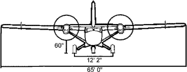
Front View
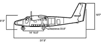
Left Side View
Twin Otter Mission Profile Information
| Auxiliary Fuel Tank Installed |
| Configuration |
Airspeed |
Endurance |
Range |
| Normal Cruise |
130 kts |
6.0 hrs |
780 nm |
| Survey Speed |
110 kts |
7.0 hrs |
785 nm |
| Auxiliary Fuel Tank Removed |
| Configuration |
Airspeed |
Endurance |
Range |
| Normal Cruise |
130 kts |
4.5 hrs |
560 nm |
| Survey Speed |
110 kts |
5.0 hrs |
565 nm |
Note:
According to FAA and NOAA AOC regulations, the aircraft must land with 30 minutes fuel reserve in VFR/day conditions, 45 minutes in VFR/night conditions, and 1 hour in IFR conditions. Additionally, endurance is relative to desired airspeed and will be reduced if flight plans include profiles (climbs/descents). Other factors influencing endurance and range include but are not limited to weather, winds aloft, and altitude. Although the auxiliary fuel tank has a maximum capacity of 150 gallons of jet fuel, the ability to carry this quantity if affected by weight limitations.
- Auxiliary fuel tank is removable.
- Dye marker drop tube is removable.
- Instrumentation hatch can be removed for continuous access to belly instrumentation and camera ports.
- Various camera mounts are available from the NOAA AOC for nose and belly camera ports.
More information about NOAA aircraft can be found at NOAA's Aircraft Operations Center.
|


