weather.gov
National Weather Service
National Operational Hydrologic
Remote Sensing Center
Home
News
Organization
Search
Home
Snow Information
National Analyses
Interactive Maps
3D Visualization
Airborne Surveys
Snowfall Analysis
Satellite Products
Forecasts
Data Archive
SHEF Products
Observations near
Science/Technology
NOHRSC
GIS Data Sets
Special Purpose Imagery
About The NOHRSC
Staff
NOAA Links
Snow Climatology
Related Links
Help
Help and FAQ
Site Map
Contact Us
Please Send Us Comments!
2008 - 2009 Snow Season Surveys
>
2009 Northeast U.S./St. Johns River Snow Survey
March 19, 2009 to March 30, 2009
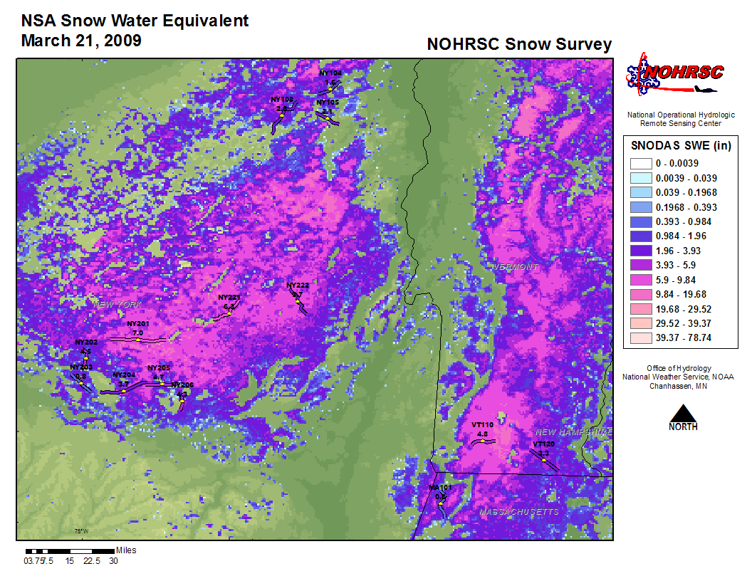
The Northeast U.S./St. John River snow survey will began on March 19, 2009. Gamma snow water equivalent measurements will be collected in the northeastern U.S. and in contributing areas for the St. John River.
Aerial Survey Photos
Flightline Status
Date
States
Status Map
Flight Line SHEF Product
SNODAS SWE Image
Interpolated Gamma SWE Image
2009-03-26
ME,NB
2009-03-26
2009-03-26
2009-03-26
N/A
2009-03-25
MD,ME,NH,NB,VT
2009-03-25
2009-03-25
2009-03-25
N/A
2009-03-21
MA,NY,VT
2009-03-21
2009-03-21
2009-03-21
N/A
2009-03-20
NY,VT
2009-03-20
2009-03-20
2009-03-20
N/A
2009-03-19
NY
2009-03-19
2009-03-19
N/A
N/A
NOHRSC
Mission Statement
|
Contact
National Weather Service
National Operational Hydrologic Remote Sensing Center
Office of Water Prediction
1735 Lake Drive W.
Chanhassen, MN 55317
Contact NOHRSC
Glossary
Credits
Information Quality
Page last modified: Feb 13, 2025 - cloud 1
About Us
Disclaimer
Privacy Policy
FOIA
Career Opportunities